Natalia Goncharova at Tate Modern

Untitled

My meeting in London finished earlier than expected and as I’d booked an Advance ticket on the train I had a few hours to kill before I could set off back home. I wasn’t too far from Tate Modern and as I hadn’t been there for a while decided I’d wander over and see what was on.

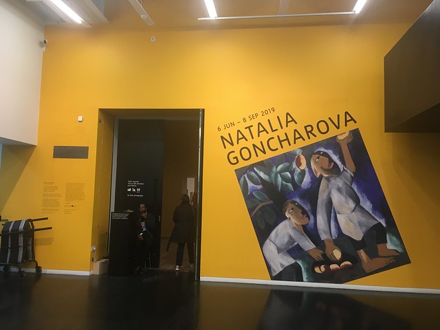
Taking advantage of my Tate membership I decided to have a look at the temporary exhibition devoted to a Russian artist from the first half of the 20th Century, Natalia Goncharova. Not someone I’d heard of before and I don’t recall seeing any of her works previously. The exhibition has had good reviews in the press, so I was interested to find out more.

Untitled
Self portrait

Goncharova came from a family of “impoverished aristocrats”, and grew up on the family estate in Tula, 200 miles from Moscow. I don’t know what the Tate mean by “impoverished”. They were certainly considerably better off than the peasants who worked on their estate. So it’s perhaps not so surprising that although her art was radical she wasn’t a supporter of the Russian Revolution. She’d left Russia and went to Paris on April 29, 1914 Goncharova came from a family of “impoverished aristocrats”, and grew up on the family estate in Tula, 200 miles from Moscow, but they moved to the capital when she was 11. I don’t know what the Tate mean by “impoverished”. They were certainly considerably better off than the peasants who worked on their estate. So it’s perhaps not so surprising that although her art was radical she wasn’t a supporter of the Russian Revolution. She’d she left Russia Paris in April 1914, stayed there during WW1 and didn’t return after the events of 1917.

The Tate’s website tells us that

Goncharova found acclaim early in her career. Aged just 32 she established herself as the leader of the Russian avant-garde with a major exhibition in Moscow in 1913. She then moved to France where she designed costumes and backdrops for Sergei Diaghilev’s Ballet Russes. She lived in Paris for the rest of her life, becoming a key figure in the city’s cutting-edge art scene.

Goncharova’s artistic output was immense, wide-ranging and at times controversial. She paraded the streets of Moscow displaying futurist body art and created monumental religious paintings. She took part in avant-garde cinema, experimented with book designs and designed for fashion houses in Moscow and Paris.

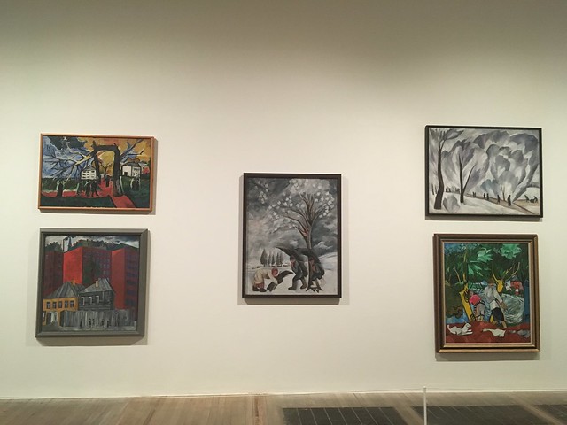
The exhibition spread over 10 rooms and featured a wide range of paintings, sketches, costumes and other items.

The 3rd room had a large number of works from a retrospective of her work held in September 1913 in the Art Salon in Moscow. There were more than 800 works in a vast range of styles. The Tate tells us

it was the most ambitious exhibition by any Russian avant-garde artist to date

and that

The term ‘everythingism’ was coined by Larionov and the writer and artist Ilia Zdanevich to describe the diverse range of Goncharova’s work and her openness to multiple styles and sources. 

These are just a small proportion of the works on display

Untitled
Untitled
Untitled
Untitled

In another room there were a number of lithographs – Mystical Images of War was published in autumn 1914 – created in response to WW1. To me they largely glorify the war (they’re certainly not critical images) and, at least to some extent, see it as a patriotic and religious “crusade”

Untitled

She was clearly religious and another room was devoted to religious paintings. I wasn’t so keen on most of them, but did like these fourApostles

The Evangelists (1911) The State Russian Museum, St Petersburg. Gift of A.K. Larionova-Tomilina, Paris 1966 © ADAGP, Paris and DACS, London 2019

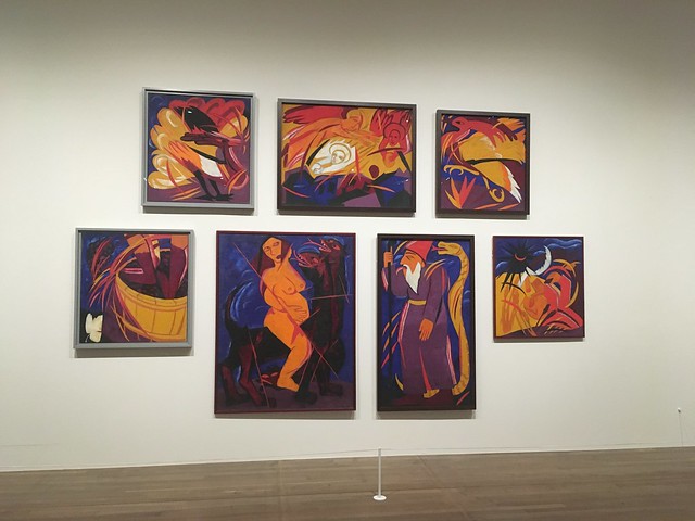
Like many Russian artists in the early 20th Century, she was influenced by Futurism. She developed her own approach which was known as Rayonism . This painting was my favourite from this room and probably from the whole exhibition.

Untitled
Cyclist 1913

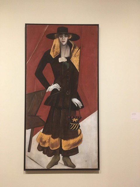
Another room featured works created while she lived in Paris. I particularly liked this painting of a Spanish woman

Untitled

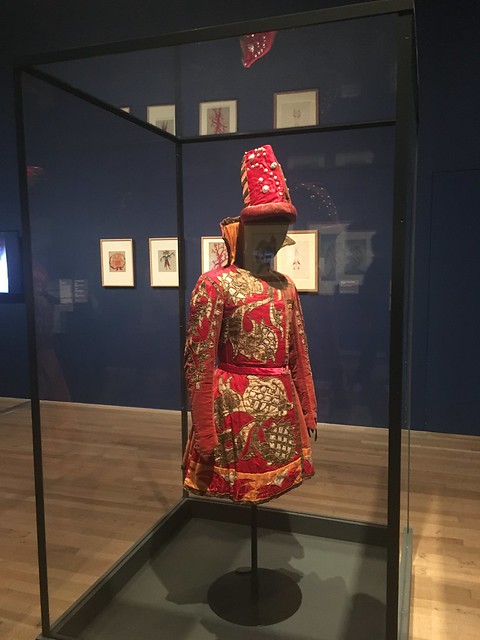
The final room was devoted to sketches, costumes and set designs from several ballet productions. Goncharova had worked with Russian composers, dancers and artists for Diaghilev  Ballets Russes creating an ‘exotic’ vision of the east . I particularly liked the costumes on display that she’d designed for a production of Le Coq d’or

Untitled
Untitled

I enjoyed looking around the exhibition. Goncharova was a talented artist and although I didn’t like everything I saw, there was plenty to keep me interested. It’s always good to discover a “new” artist (well, new to me!) so I wasn’t disappointed that I had a few hours to kill before my train.

Later that afternoon I received a text from Virgin Trains to tell me my train had been cancelled. Fearing the worst – that there was major disruption – I was relieved to find that it was due to the train breaking down. Arriving at Euston a little early I was able to transfer on to the train before and managed to get home half an hour earlier than expected. So all worked out well in the end!

A walk around Arnside

Untitled

The Saturday after I’d been to London I felt like I needed to get out for a walk, but nothing too strenuous after a busy week, but something that would blow the cobwebs away. I didn’t fancy driving so decided I’d get the train over to Arnside for a route that would take me along Morecambe Bay and up the small hill known as Arnside Knott.

It was rather grey and overcast when I arrived, but the thick cloud soon cleared leading to a warm, sunny day.

DSC06418

From the station I walked over to the “prom” and set out along the Kent estuary towards Morecambe Bay. The tide was well out, revealing the expansive flat sands. They looked harmless enough but many people have lost their lives in the treacherous quicksands or when the tide rushes in “faster than a running horse” No danger of that today, the tide wasn’t due in for several hours and the siren announcing the turn of the tide only sounded when I was safely back in Arnside at the end of my walk.

DSC06419

DSC06422
DSC06423
Looking over to Grange and Humphrey Head on the other side of the Kent estuary
DSC06425
Looks like one of the markers used by the Queen’s Guide. Perhaps preparing for a walk over the sands?
DSC06427
Some of the Lake District Fells visible in the distance
DSC06428

With the tide well out I strayed deep ont the sands before returning to the shore at Far Arnside. I then crossed a couple of caravan sites and took the path up towards Arnside Tower.

DSC06430

The ruined building is a Pele Tower, one of many  small fortified keeps or tower houses, built close to the English and Scottish borders from times when these lands were plagued by raiders and reivers.

DSC06432

Descending th e hill I spotted that since the last time I was around here the farm near the tower had opened a cafe that was open at weekends and school holidays, so I stopped off for a brew

DSC06438

Refreshed on a hot day I carried on towards the Knott

DSC06437

climbing up through the woods

DSC06439
DSC06440

After a short climb I reached the ridge and was greeted with great views over the Kent estuary towards the main Lakeland Fells in the distance

DSC06442
DSC06451
DSC06453
DSC06454

and over Morecambe Bay, where the tide was still well out

DSC06455

After taking in the view while I had a bite to eat, I set off back down the hill towards Arnside via the estuary.

Untitled
DSC06458

I followed the shore back to the prom

DSC06460
Untitled

where I treated myself to an ice cream which I ate sitting on the small pier looking over the railway bridge (tide still not back in!)

DSC06459

It was nearly time for the train – a direct one back to Wigan so no need to change at Lancaster!

Untitled

so only just over an hour after boarding the train I was back home after an enjoyable day’s walk.

The One and the Many

Untitled

The reason I’d decided to wander over to Fitzrovia while I was in London last Wednesday was that I wanted to take a look at a sculpture by a favourite contemporary artist, Peter Randall-Page, which is sited in a new development, Fitzroy Place, off Mortimer Street. It’s right next to the Fitzrovia Chapel, a Grade II listed building was the former chapel of The Middlesex Hospital.

Untitled

The One and The Many’, is sculpted from a 24 tonne naturally eroded granite boulder and inscribed with many of the world’s scripts and symbols. 

Untitled

The scripts carved on the work are all related to cosmology and the material/poetical formation of the universe. I shot a few close ups.

Untitled
Untitled

Translations of all the scripts can be seen on a website devoted to the sculpture. The website also includes some photographs of the artist at work on his creation.

Art Deco London

Work is taking me down to London a few times during June and July. The first of three visits took place last week. I caught a train late Wednesday afternoon ready for a meeting the next day. It’s not much fun sitting in a budget hotel room near Euston, so I decided to get out for a wander around Bloomsbury and Fitzrovia.

London’s a different world from a northern town like Wigan. So much more hectic and busier and with a lot more activity and things to see even while just mooching about. I’m fairly familiar with Bloomsbury as you’re in the district as soon as you step outside Euston station, but, even so, I often spot something I’ve not noticed before while I’m out “street haunting”.

Bloomsbury and nearby Fitzrovia are noted for Georgian and Regency architecture. But in amongst the neo-Classical squares and crescents there are other types of buildings, including a few in the Art Deco / “Streamline Moderne” style from the 1930’s. Here’s a few photos – some I’d seen before but a few I’d noticed for the first time. The light wasn’t great for photos, unfortunately, but here’s a few snaps anyway.

Untitled
Block of flats on Coram Street, Bloomsbury
Untitled
Former Bentley Garage
Untitled
University College London, Senate House, off Russell Square
Untitled
The doorway of the London School of Hygiene and Tropical Medicine
I sat my BOHS Certificate oral examination in this building many years ago
Untitled
This building on the Edgeware Road looks like it used to be a cinema
Untitled
Broadcasting House, the headquarters of the BBC, on the corner of Portland Place and Langham Place, Fitzrovia. The first radio broadcast from the building was made on 15 March 1932
Untitled
The sculpture of Prospero and Ariel  by Eric Gill on the facade of Broadcasting House.
Untitled
Middlesex House in Fitzrovia. A 5 storey office building erected in 1934 that was previously a garment factory
Untitled
Another view of Middlesex House

Moel Famau and Moel Dywyll from Loggerheads

IMG_1855

I’m slightly ahead of target for me 1000 miles challenge having done quite a bit of walking during May. But with June being something of a damp squid so far I’ve been keeping my eye on the weather forecasts for the hills within a couple of hours drive from home. Last weekend the Lakes and Dales were looking wet, but there seemed a good chance of reasonable weather in the Clwdian Hills in North Wales. So on Saturday I set out early and drove over to Loggerheads, between Mold and Ruthin, and only just over an hour from home, providing the traffic on the M6 and M56 is moving (not usually a given!)

I arrived at Loggerheads Country Park just as it started to absolutely chuck it down. But I wasn’t going to let that stop me, so I paid my car parking fee at the pay and display machine and got into my boots and coat, locked up my car, put my rucksac (equiped with its waterproof cover) on my back and set off walking. The downpour lasted no more than half an hour and that was the last I saw of up until I arrived back home later in the day, where it had poured down all day. North Wales was definitely the place to have been!

I’d plotted a route that would take me up Moel Famau and then along the ridge before cutting across country and back to Loggerheads via the Devil’s Gorge. I’d been up Moel Famau before but took a different route upto the top. That might have been a mistake as this time the route took me through some very soggy fields and a couple of swollen streams. I knew this was a risk and had intended to wear my gaiters, but I’d forgotten to put them in the car. My boots proved they were waterproof but the bottom of my trousers got rather wet. But my walking trousers of choice these days are Rohan Stretch Bags which, being made of a soft shell type material, don’t soak up the water and dry off very quickly. Consequently, I don’t bother with waterproof over-trousers any more.

As I set off down the narrow lane from the car park the rain eased off and had soon stopped.

Untitled

After less than a mile I was off the tarmac and walking down a gravel path.

DSC06360
DSC06363
IMG_1853

Then on over a stile into a grassy field, skirting a forest, through a stream, which required a paddle as the stepping stones were covered with water,

DSC06365

through another wet and muddy field, through another stream, and along a track,

DSC06366

before turning off up a steep path through forest that would take me to the top of Moel Famau, the highest hill in the Clwydian range – modest by North Wales standards at 1821 feet, so not high enough to be called a mountain.

DSC06367
DSC06370

The top of the hill is crowned by Jubilee Tower built to commemorate the golden jubilee of George III in 1810. It was never finished due to lackof funds and after a major storm in 1862 the upper part of the structure was demolished for safety reasons so today only the base is left.

DSC06372

As it’s the highest point for miles around, on a clear day there are views in every direction, over the Dee and Mersey to Liverpool and beyond, to the Irish Sea in the west and over the Vale of Clwyd right over to the mountains of Snowdonia to the south. Visibility wasn’t bad as I stopped for a while for a hot coffee from my flask and a bite to eat, but it was windy.

DSC06373
DSC06374
DSC06376
DSC06378

Offa’s Dyke path goes over Moel Famau, and then on along the ridge before descending on to the coastal plain and then on to the sea at Prestatyn. After eating I followed the path west along the ridge over the next summit, Moel Dywyll (try pronouncing that!).

IMG_1861

Great views all along. I’d have liked to have carried on and climbed the next major peak, Moel Arthur, the site of an Iron Age hill fort ( there are several on the Clywidian Hills) but that was a little too far as I needed to cut across back to Loggerheads. So reaching the bwlch (another difficult to pronounce Welsh word, equivalent to the Lakeland “hawse”) I turned off taking a path down from the ridge.

DSC06384
DSC06386
Looking back to Moel Famau
DSC06388
DSC06391
The Snowdonia mountains in the distance
IMG_1864
Moel Arthur ahead

The path descended gradually and was soggy in places,

DSC06394
DSC06396

but after a while, after skirting a small reservoir, I was on firmer ground that turned into a track and, after a while, a tarmaced road.

DSC06397

I carried on along the quiet road a little further than I’d intended as the riverside path was a little dodgy due to the recent heavy rainfall, but I cut across fields back to the river just east of Cilcain. A short walk along the road, up a steep hill, and then I joined the Leete path that would take me high above the river along the valley on towards Devil’s Gorge and then back to Loggerheads.

DSC06399
DSC06402
DSC06404

This is limestone country and the cliffs above the River Alyn are riddled with disused lead mines.

DSC06403

The Devil’s Gorge is a 30 metre deep gorge leading to caves which were created during mining many years ago.  It’s apopular spot for absailing and rock climbing. I’ll stick to walking myself, thankyou! Although you can descend down to the river for a closer look, (and I did – on foot, down a path) the main Leete path crosses a high bridge over the gorge so I had to clamber back upto rejoin the route

IMG_1868
DSC06405
DSC06406

The Leete was an artificial watercourse which drew water from the River Alyn near the mill at Loggerheads and carried it three miles to Rhydymwyn along a much shallower gradient than the river itself, meaning that for most of it’s length the channel was well above the river bed. The water was needed to drive water wheels used to pump excess water from the lead mines that lined the valley, providing a reliable supply particularly during the in summer, when the river itself vanishes into swallowholes in the limestone riverbed. That wasn’t happening today as the river was in full spate causing some sections of riverside path to be closed.

DSC06410

Entering the Country Park

DSC06411
DSC06412

Loggerheads was an important lead mining area during the 18th and 19th centuries.

DSC06416

There was some evidence of this industrial past in the Country Park, although today, it is partially hidden within the woodland that developed once the mining had ended. Approaching the end of the trail I passed a wheel pit which had originally housed a waterwheel used to drain a mine located on the opposite side of the river.

DSC06414
DSC06415

I soon reached the Florence café and “tea gardens”. It was a pleasant afternoon so we enjoyed a pot of excellent tea and a slice of Bara Brith (a Welsh fruit cake)sitting outdoors before returning to the car for the drive home.

Place Fell

DSC06331

June has been rather a damp squid so far. Lots of rain. Despite this, by keeping an eye on the weather forecast I’ve managed to get out for a couple of walks, largely avoiding getting wet and enjoying a little sunshine.

The first of these was last Sunday when, after a washout of a day on the Saturday, it looked like it could be reasonably clear up in the Lake District, so I set off early and drove up to Ullswater.

I parked up in Glenridding and walked over to the pier. My plan was to take the Steamer over to Howtown and walk back to Glenridding via Place Fell.

I bought myself a one way ticket and boarded the steamer for the half hour journey over to Howtown.

Untitled

It’s a pleasant trip, with good views over the surrounding fells

DSC06261
DSC06271
DSC06264

The steamer was busy and many of the passengers were walkers who disembarked at Howtown. But most of them were following the lakeside path back to Glenridding so we soon parted ways as I took the path to the south of Hallin Fell.

Looking back to Howtown and Ullswater

DSC06289

There were good views down Martindale, one of the less frequented Lakeland valleys

DSC06293

Approaching the hamlet of Sandwick, the “foothills” if Place fell came into view

DSC06297

I’d soon be starting the climb up the fell, but before that I had to cross the river

DSC06300

As I climbed, looking back, there was a good view over Ullswater

DSC06303

And there were a couple of the Steamers, passing each other as they made their way across the lake

DSC06302
DSC06307

I passed the disused quarry with it’s ruined buildings

DSC06309

The summit came into view

DSC06308

Up til now I’d hardly seen a soul since I left the lakeside path at Howtown, but now it was rush hour! The Howtown fell race was taking place

DSC06311
DSC06317

Still a way to go to the summit

DSC06312

Continuing to climb

DSC06315

One of the small tarns near the summit

DSC06318

Made it!

DSC06322

It was windy on top but I managed to find a sheltered spot to grab a bite to eat.

Place Fell is a relatively modest mountain, but it’s well placed with 360 degree views on a fine day

Looking down to Glenridding and Helvellyn

DSC06323

across Ullswater

DSC06324

Towards High Street and the Far Eastern Fells

DSC06326
DSC06327
DSC06328

I stayed a while and then started to make my way down the fell

The view down to Patterdale and Grisedale where I’d walked only a few weeks before. No snow on the tops today, mind.

DSC06334

Descending down to Boredale Hawse

DSC06335
DSC06340
DSC06341

Looking back up to Place Fell

DSC06343

A view of Patterdale and Ullswater as I dscended

DSC06349

The view towards the Kirkstone Pass

DSC06350

Reaching the bottom of the valley I stopped for a brew and a slice of cake at the tearooms at Side Farm

Untitled

On the path towards the road at Patterdale I looked back to take in the view of Place Fell

DSC06352

There was a walk for just over a mile along the road from Patterdale back to Glenridding. I paused to take at look at St Patrick’s church

DSC06353

It was a grand walk, with the added bonus of a trip across the lake on the steamer! There are plenty of options of walks from Howtown in an area away from the crowds gathering at the honeypots on the other side of the lake. I certainly fancy exploring the fells around Martindale. And there’s other possible routes over Place Fell as well. A return definitely on the cards.

Untitled

Glendalough Monastic City

Ireland 2010 201

Before and after my walk around the two lakes at Glendalough I took the opportunity to look around the Monastic City, an early Christian monastic settlement founded by the Celtic saint, St. Kevin (Caoimhín in Irish) in the 6th century although mst of the surviving buildings are from the 10th to 12th centuries. It’s one of the most popular tourist attractions in this part of Ireland being only an hour’s drive from Dunblin. I’d visited the site with my wife 9 years ago, but thought it was worth another look.. 

The view towards the site is dominated by the 33 metre tall Round Tower.

DSC06208

It was built almost 1000 years ago by the monks of St. Kevin’s monastery. Round towers are found all over Ireland and there are various theories about what they were for. However, the Irish name for the towers is “Cloigtheach”, which translates as “bell tower”. It is also thought that the towers were sometimes used as a place of refuge for monks when the monastery was under attack from Vikings and other raiders. They may also have been used as lookout posts and as beacons foe approaching monks and pilgrims. The Glendalough tower is a fine example, many others are partially ruined, although the conical roof had to be replaced in 1876 after it had been struck by lightning.

Ireland 2010 192
Ireland 2010 181

St. Kevin’s Church better known as St. Kevin’s Kitchen is a nave-and-chancel church of the 12th century. It is called St Kevin’s kitchen because people believed that the bell tower was a chimney to a kitchen.

DSC06119
DSC06113

The Cathedral is the largest of the seven churches around Glendalough.  It was built in several phases from the 10th through the early 13th century.

DSC06117

Originally, the site was enclosed within a circular wall. Most of this has gone but gateway remains and is Ireland’s only surviving example of a medieval gateway to an early monastic city. The arch is built with Roman style columns and the stones were cut specifically to scale and they held themselves up without the need for mortar.

Ireland 2010 198

North Bull Island

Untitled

At the end of my weekend in Wicklow I was booked on the afternoon ferry from Dublin to Holyhead. I had to check out ofthe campsite mid morning so had planned to drive over to Dublin, park around either Merrion or Fitzwilliam square and have a mooch and visit one of the galleries in thecity centre. It didn’t quite work out like that, though. Driving in there were signs regarding a half Marathon and when I arrived in the city centre found that both Merrion and Fitzwilliam squares were closed off as the starting and finishing points for the race. So I had to change my plans.

I reckoned that with the half Marathon on it would be busy in the centre and parking might be difficult. I also thought I could get tangled up in traffic and diversions when it was time to drive across the city to the port. So what to do? I decided to drive over the Liffey and then across to North Bull Island, a low lying, dune covered sand spit in Dublin Bay off the coast of the city’s north side which I see every time I sail in and out of the port. It was a sunny day so a good opportunity to visit the island and take a walk on the beach.

Untitled

The Island was created 200 years ago following the construction of the 1 kilometre-long North Bull Wall was constructed to prevent the port silting up. The surveying of the river prior to the building of the wall was done by a certain Catain Bligh of Bounty fame. Sand gradually accumulated behind the wall forming the island. Today it’s 5km long by 1km wide and it’s still growing. It’s important ecologically and has been designated as a National Bird Sanctuary, a biosphere reserve, a National Nature Reserve, a Special Protection Area under the EU Birds Directive and a Special Area of Conservation under the EU Habitats Directive. That’s a lot of designations!

The island is easily accessible as it’s connected to the mainland by the Bull Bridge, a one-lane wooden road bridge at the southern (Clontarf/Dollymount) end, and by a causeway, approximately halfway along at Raheny. After cutting acoss the city centre, I drove along the front and then crossed over to the island via the causeway, parked up and wandered past the dunes to the sandy beach known as Dollymount Strand.

Untitled

The strong wind was in my face as I walked along the beach towards the Bull Wall, but there were plenty of other people out exercising and otherwise enjoying the sunshine. There are views out to sea and over to both Howth Head and the port.

Untitled
Untitled

I could see right over Dublin Bay to the Wicklow Mountains. Completely free of cloud today. Typical!

It’s a popular spot for wind surfing and it seemed like a good day for it.

Untitled

As I walked along the beach I could see the Stena ferry I would be boarding later sailing in. I got some good shots of it as I reached the end of the wall just as it sailed past. Good timing!

Untitled

Although the sea was quite rough there were a number of bathers who’d taken the plunge. Rather them than me!

Untitled

I retraced my steps aling the beach and then back to my car. It was time to drive the short distance to the port ready to board the ferry back to Holyhead.

A walk into the cloud

I woke early on the Saturday morning during my stay in the Wicklow Mountains. I’d checked the weather forecast the night before and wasn’t very optimistic as rain was expected. It wasn’t raining when I got up, but after breakfast, when I popped down to the village to pick up some supplies, it arrived. I hung around in my pod for a while but there was no sign of it stopping. However, I had my waterproof coat and I wasn’t going to let a little rain stop me from getting out onto the hills.

I’d plotted myself a walk from the campsite that would take me to the top of Scarr, a mountain 2105 feet high just a few miles north ofthe site. I’d worked out a couple of possible circular routes, but hadn’t any definite plans as to which I would follow, I thought I’d see how it went depending on conditions.

I set out along the Military Road (as the name implies it was built by the British to facilitate the movement of troops to keep the Irish under the imperial heel)

DSC06224

for about half a mile until I reached the point where the Wicklow Way crossed the road.

DSC06225

Turnng right I followed the trail up through a forest,

DSC06227
DSC06228

climbing on to moorland. The rain began to ease off and had more or less stopped by the time I came out of the cover of the trees.

I continued on the Wicklow Way for a while across the moor before turning off on a path that would take me over Paddock Hill towards Scarr. Views were opening up over the Glenmarcnass Pass to the Mullaghcleevaun, Tonelagee and Brockagh mountains, or at least they should have been! Low cloud was was covering the mountain tops.

DSC06236
DSC06229
DSC06235

I carried on over the moor and started the climb up Scarr,

DSC06240

up into the cloud that was covering the mountain.

DSC06241

I stopped to chat with some walkers on their way down. They’d been to the summit but as visibility was poor were making their way back down towards Laragh. I carried on.

DSC06242

It was a gradual climb; nothing too steep but due the cloud I couldn’t see the top. A couple of times I thought I was there but then realised that it was a false summit.

DSC06243
Untitled

Eventually I made it to the top. I couldn’t see a thing!

DSC06244

I’d planned to carry on to another peak, Kanturk, a little further along the ridge, and then loop back. But given the lack of information on the maps I decided there was a real chance of getting lost so, reluctantly, turned back to retrace my route.

After turning round there was a break in the cloud – I could see the summit!

DSC06248

and some of the nearby countryside

DSC06249

I hung around for a little while to see if it was going to disperse so I could resume my original plan. But it was a false hope, it soon closed back in

I retraced my route back over the moor and then down through the forest

DSC06254

Reaching the Military Road, rather than walk straight down into Laragh, I crossed over and followed the Wicklow way for a while, down through more forest

Crossing over a recently constructed bridge over the turbulent river

DSC06258
DSC06259

rried on along the path I’d have reached the monastic site at Glendalough, but I cut down through a forest track back to the village where I picked up some supplies from the convenience shop.

Despite the conditions it was an enjoyable walk. I’ll have to return one day and repeat it when the weather’s a bit better.

After a shower and something to eat it was soon time to head down to the local pub to watch the match.

A walk around Glendalough

DSC06154

About 9 years ago, during a holiday touring around the south west of Ireland, we visited Glendalough – “the valley of two lakes” – in the Wicklow Mountains. The old monastery at the end of the glacial valley near Laragh is one of the most popular tourist sites in Ireland, as it’s an interesting monument about an hour’s drive from Dublin. We’d looked around the ruins but then went for a walk along the lake, up the valley as far as the old miner’s village which is just past the end of the Upper Lake. At the time I would have liked to follow the trail around the valley, climbing up to the Spinc, the hill that overlooks the valley to the east of the lakes, but didn’t have time that day. But I’d always wanted to go back. So while I was staying in Laragh I was able to fulfil my ambition.

After checking into my pod and unloading the car, I changed into my walking gear and set off from the camp site through Laragh and then joined the “green road” which would take me to the monastic site and the start of the glen; a very pleasant walk of just over a mile.

Untitled
DSC06112

I diverted for a quick look at the monastic site, which was, not surprisingly, heaving with tourists of various nationalities. But I didn’t stop for long as my main objective was to follow the white route, one of several waymarked paths around the area. To reach the start of the route I followed the boardwalk which had been constructed across the bogs along the side of the Lower Lake.

DSC06120

There was also a continuation of the Green Road along the other shore, but I’d decided that I’d follow that on the return leg.

Glendalough trails

It was interesting to cross the bog and the boardwalk kept my feet dry!

DSC06122
Looking over the Lower Lake from the boardwalk

I emerged at the bottom of the Upper Lake where there’s a car park, a toilet block, some vans selling food and drinks and an information centre. I picked up a trails leaflet and some information on the Wicklow Mountains National Park and then bought myself a brew which I drank sitting on the shore of the Upper Lake, taking in the view up the valley.

DSC06126
The view up the Upper Lake

Refreshed, I set off on the White route. I decided to follow it in a clockwise direction, thinking that I’d rather go up the initial steep climb past the Poulanass waterfall and up through the forest to the top of the Spinc (from the Irish “An Spinc“; meaning “pointed hill”) than come down it at the end. The descent at the top of the lake was much more gradual and so likely to be easier on the knees. I think that was the right decision.

DSC06129

I climbed the steps, passing the waterfall.

DSC06130
DSC06136

A walk along a section of forest road then took me to the start of the trail up through the forest. It was a steep climb, made easier by the steps (600 or so of them), made of old railway sleepers.

Untitled

The sleepers been used to create a boardwalk, a dry track all along the route on the east side of the lake, up to and along the Spinc. Much of the route is over boggy ground so it saves walkers having to yomp through mud and also protects the ground from erosion.

Large areas of trees had been felled leaving a desolate landscape to the east of the path.

DSC06139

But this did make the climb less claustrophobic and dark than if the trees were all still standing and it opened up the views

DSC06142
Looking back down the hill

Eventually I reached the ridge and as I followed the path there were several viewpoints over the Lake and up and down the valley.

DSC06143
DSC06144
DSC06145
Untitled
Looking down on the two Lakes from the top of the Spinc

There were other walkers following the route in an anti-clockwise direction, some not really suitably attired, but, luckily, the weather, although cloudy and a little windy, wasn’t too bad. It deteriorated a little as I carried on up the valley, but although it started to rain it didn’t last long.

DSC06148
DSC06155

After climbing to the summit, the route started to descend down towards the Glenealo Valley. I’d noted that quite a few of the sleepers were beginning to deteriorate but I could see that work was taking place to renew them – it had already been done on a long stretch at the south end of the ridge.

DSC06157
DSC06162

As the path descended the wooden boardwalk ended and I found myself on a rocky path heading down to the bridge which crosses the river.

DSC06167

As I descended I spotted a herd of feral goats above me on the hillside. There’s several hundred of them living in the valley so There’s a good chance of encountering them on a walk here. It’s not certain whether they are descended from goats kept by the former miners or whether they were already here when the mine first opened.

DSC06172
DSC06176
DSC06187
DSC06179

After crossing the bridge the route turned north and continued to descend down towards the Upper Lake and the old Miner’s Village.

DSC06180

I spotted a couple of young men who clearly had spotted something and were taking photos. When I reached them I could see what was attracting their attention – a deer standing only a few yards away from them. I managed to take a few photos myself.

DSC06185

As with the goats, there’s a large number of deer roaming around Glendalough, mostly crossbreeds between native Red Deer and Japanese Sika (which had escaped from the Powerscourt estate). They’re used to walkers and, apparently, often get relatively close, as in this case.

DSC06186

Carrying on descending down the rough, stoney path – time to start using my walking poles – I eventuallyreached the ruins of the Mining village. There’s been mining in this area of the Wicklow Mountains since about 1809 and the mine high on the hillside operated between 1825 and 1925, extracting lead ores and some silver. It re-opened briefly between 1948 to 1957 but has been closed permanently since then. Spoil heaps are still clearly visible on the mountainside above the village.

DSC06190

I stopped for a little while to look around the ruins.

DSC06191
DSC06193
Looking back up the valley past the Miner’s Village

I carried on along the path which soon turned into a track along the west side of the Upper Lake,

DSC06194
DSC06195
Looking back up the valley – The rain had come in
DSC06196

so it didn’t take me too long to reach the end of the White Route at the bottom of the lake. I stopped to look up the valley where it was now misty as the rain was falling.

DSC06200
Looking back up along the lake with the Spinc on the left
Untitled

I took the Green Road path back along the Lower Lake, stopping briefly to take in the views.

DSC06201
DSC06204
DSC06205

Reaching the monastic site just after 6 o’clock I stopped for a while to take a look as the bulk of tourists had gone. The sun popped out of the clouds briefly, lighting up the round tower.

DSC06208
DSC06215

Retracing my steps back along the Green Road through the forest

DSC06217
DSC06221

I reached Laragh around 7 o’clock. I picked up a few supplies from the convenience store and headed back to the campsite. It was time to make myself something to eat.

It had been an excellent walk, which didn’t disappoint. I quite fancied trying some of the other trails but I had different plans for the next day so will have to return some other time. I’m due back in Ireland in September so may get the chance to stay for another weekend – we’ll see!

After eating I sat outside on the decking reading for a while, with a coffee and a bar of chocolate (after a 12 mile walk, I think I deserved a treat). When the night drew in I turned in early and settled down to sleep. I had plans for another walk the next day.