Back on the cliffs at Whitburn

The week after we’d been to the galleries in Manchester I was up in the North East with work, so I took the opportunity to visit some family in Whitburn. After a tiring drive along the M61, M62, A1 and A19 I parked up near the Souter lighthouse for a short walk on the cliffs to clear my head during the last hour of sunlight on a cold January day.

With the light fading and cloud coming in, I returned to the car and drove the short distance to my relatives house for a welcome cup of tea.

Sunset on the cliffs at Whitburn

5B03C956-1E4B-4552-B18C-56152ABFE0E0

Last week I was up in the North East with work. An intersting project for my second, part time academic job! I used this as an opportunity to visit some of my relatives up there and they were kind enough to put me up (and put up with me 😉) for a couple of days. I drove up on the Monday planning to arrive before sunset. As it happend I got there quicker than expected so decided to stretch my legs and get some fresh air after a long drive.

I parked up near Souter lighthouse and strolled along the cliffs. During the walk the sun began to set and I was treated to a glorious sky lit up red and gold, reflected in the sea. My photos, snapped on my phone, don’t really do justice to what I saw.

AEBF8F76-BA80-49AA-960A-5EAE269E3120
438796C6-8DA0-46E3-B7A1-196BD1B91F3C
78F46045-D18E-4E25-ABD2-3DFE46846C74

A walk along the cliffs

Last Monday, before setting off on the long drive home, we took a couple of hours to go for a walk on the cliffs north of Whitburn near Souter lighthouse.

The lighthouse opened in 1871 and was the first in the world with an electrical powered lamp. It was decommissioned in 1988 – but not before the foghorn kept me awake during my first visit to Whitburn, when it operated throughout a foggy night, while we were staying at J’s auntie’s house (the house where she was born!).

DSC09528

Battered by the sea and the elements, the cliffs are eroding, a process being accelerated by climate change. Since we were last here, sections of the coastal path have been diverted due to safety concerns

DSC09523
DSC09539
DSC09515
DSC09512

The cliffs are home to sea birds, including Kittiwakes, Fulmar, Cormorants, Shags and Guillemots.

DSC09514

To the south of the lighthouse, the coastal path descends and there is access to a small cove known as the Wherry, a popular local recreation spot in the past when fishing boats were kept in and launched from the cove.

DSC09534
DSC09532

There’s a lot of history in the area. Although today the coast between Whitburn and South Shields are owned by the National Trust the top of the cliffs is a pleasant lawned area not that long ago they were dominated by industry with a coalmine (Whitburn colliery) lime kilns and a railway running along the top of the cliffs. There’s no sign today of the mine, (where my wife’s grandfather used to work) but the old lime kiln just over the coast road still remains as a reminder of the industrial past.

DSC09519

The Marsden Banner Group have some good information on the history of the colliery and the village on their website.

Another walk along the shore in Sunderland

During our short break in Sunderland last weekend we stopped for a couple of nights with a relative who lives near Roker Park, close to the south end of the beach that stretches north to Whitburn. On Sunday, we wanted to visit some other family members who live in Marsden, not far from the Souter lighthouse. It was promising to be a nice day so we decided to walk the few miles along the coast. When we attempted a similar walk over the Easter weekend, we were thwarted by a very heavy downpour. But this time there were no problems.

It was sunny when we set off but when we reached the Prom sea mist was rolling  obscuring the view of the south pier and lighthouse

DSC08525

It was rolling in and out on the wind, making for some atmospheric views of the beach.

DSC08527

DSC08530

DSC08529

As we proceeded north, the mist was dispersing and “burnt off”

DSC08531

although it was still lingering somewhat out at sea.

DSC08533

At the end of the beach, we followed the path along the cliffs passing several smaller coves. We spotted this man made circle of stones in one of them.

DSC08534

DSC08537

DSC08542

After spending a few hours with our relatives we set back, retracing our steps.

DSC08538

It was a beautiful day, if a little chilly down on the beach due to the sea breeze

DSC08544

DSC08545

The local council are doing a lot of work renovating and refreshing the prom

DSC08546

The tide was in when we reached Roker

DSC08547

And the mist had gone – so we had a clear view of the south pier and lighthouse from the prom.

DSC08549

On the Cliffs at Whitburn

P1080375

Last weekend we went up to the North East visiting family. On Sunday afternoon we took a couple of hours to go for a walk on the cliffs north of Whitburn near Souter lighthouse. It was quite windy and fairly sunny, but with some heavy showers. Our walk was sandwiched by heavy downpours but we managed to keep dry.

The coastline is quite stunning with rugged rocks, cliffs, caves and coves,

P1080377

2013-08-11 13.00.02

with cormorants and kittiwakes nesting on the rocks.

P1080372

Battered by the sea and the elements, the cliffs are eroding, a process being accelerated by climate change. The National Trust recently had to close a road and cliff top car park as the cliffs at that point are undermined by caves and could collapse at any time.

P1080374

There’s a lot of history in the area. Although today the coast between Whitburn and South Shields are owned by the National Trust the top of the cliffs is a pleasant lawned area not that long ago they were dominated by industry with a coalmine (Whitburn colliery) lime kilns and a railway running along the top of the cliffs. And next to the lighthouse, on top of the cliffs there was a village built to house miners from the colliery, and exposed to the wind and rain  and, on foggy days, blasted by the noise from the lighthouse’s foghorn. Today they are all gone, except for the ruins of the lime kilns. You’d never know they’d been there.

(Image from Marsden Banner Group website)

(Image from Marsden Banner Group website)

The Marsden Banner Group have some good information on the history of the colliery and the village on their website.

To the south of the lighthouse, the coastal path descends and there is access to a small cove known as the Wherry.

P1080380

P1080386

The tide was out exposing an expanse of limestone pavement

2013-08-11 14.02.59

P1080384

P1080389

The Wherry was a popular local recreation spot in the past and fishing boats were kept in and launched from the cove. There was a picture showing a couple of boats on an information panel on the path near the cove.

P1080391

After our walk, talking to one of our relatives we discovered that one of the boats pictured belonged to his grandfather.

By the sea at Sunderland

Mention Sunderland and most people will probably picture a northern industrial town struggling (like most northern towns) to overcome the north-south divide and bias towards the south of England, or a middling Premier League football club with quite a nice stadium. They wouldn’t be wrong. But there’s more to Sunderland than that. Although it’s on the coast, most people are probably not aware that it’s quite a pleasant sea-side town as well with a beautiful sandy bay extending across the Roker and Seaburn districts, which are just north of the city centre.

image

The bay extends for a mile or so from the old port in the south at the Roker end to the start of the cliffs at the north of the Seaburn stretch of the bay. There’s a promenade extending along the full length of the beach which has a blue flag status. When the tide goes out there’s a large, flat sandy each. I reckon the sea must be pretty cold all year round – it is the North Sea after all – but it’s popular with surfers as well as children who want to splash in the water (and some adults too).

There are the usual typical features of the English seaside with a stretch of cafes, restaurants and fish and chip shops, and a small funfair. The buildings on the promenade at the southern Roker end are mainly hotels and guest houses while the north end of Seaburn is a little more up market, dominated by housing.

The painter L S Lowry, who hailed from Manchester, used to come up to Seaburn for holidays in the Seaburn hotel – now long gone and replaced by a block of flats –  and there are a number of his paintings and drawings featuring the sea and promenade. Some examples can be seen here.

Pencil drawing by L S Lowry “A Promenade” (1960) Source here

We were up there earlier this week visiting family and, as we usually do when we travel up to Sunderland, we found some time to have a walk along the promenade and on the beach. It was a cold day with a grey sky, but it’s always nice to take in some sea air. The sea was fairly rough and there were a number of surfers  riding the waves. We also saw three very hardy children dressed in their swimming costumes braving the cold water.

6887276083_6b0735d3b3_o

We’ve walked along the promenade and beach a few times during previous visits during the spring and summer where I’d taken a number of photos.

image

Roker beach during the summer

image

Looking out to sea from Seaburn promenade

image

Looking towards the promenade from the end of the pier on a summer evening.

image

Fishermen on the pier at sunset on a summer evening

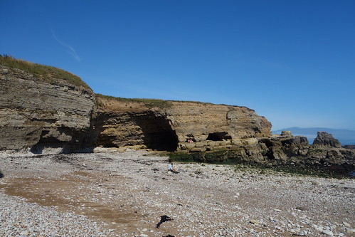
After eating some fish and chips for our dinner (or lunch if you’re from the south) we drove a mile further north along the coast, past Whitburn up to Souter Lighthouse where we parked up and went for a walk along the cliffs. The land along the coast from Whitburn up to South Shields is now owned by the National Trust and has been preserved from development, creating a coastal park making it possible to walk all along the coast from the old port at Sunderland to South Shields.

At one time much of this land was industrial with Souter lighthouse sandwiched between the Marsden pit to the south and Marsden Village, built to house the miners, to the north. All of this is long gone. The pit was closed in the late sixties and it was demolished son after along with the village.

image

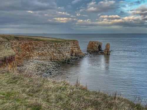
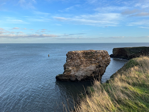
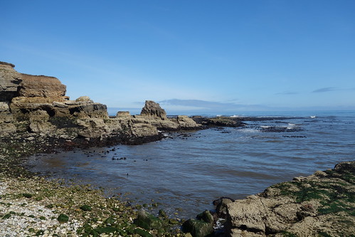
Today there’s a pleasant walk along the cliffs from which there are some stunning views of the rocky coastline and out to sea.

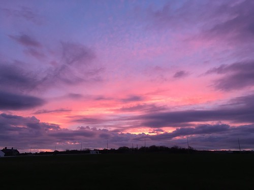
The sky was grey and dramatic and the sun kept breaking through the clouds lighting up the crests of the waves and creating some interesting effects.