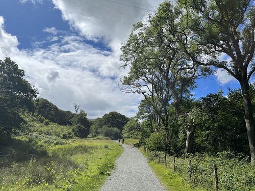
We left the sun behind yesterday and drove over to the cooler and cloudy North Wales coast. Our first destination was Aber Falls. I’d been there a couple of times, the last time as an add on to a lengthy circuit along the coast and amongst the Carneddau foothills on a surprisingly fine day in February. This time I was with J who wanted an easier wander, so we parked up in the car park at the top end of the village and did a “there and back” along the track to Rhaeadr Fawr – the large falls. The cloud base was quite low and the tops of the hills were hidden, but it created quite a moody atmosphere. It was cool, but not cold and still tee shirt weather.
I’d told J it was a flat route – but, of course, flat is a relative term. Still, it’s not a difficult walk with plenty of interest, including the site of a prehistoric settlement
and a spectacular climax
Close up to the falls it looks impressive, although the top part of the cascades can’t be seen from this angle
and you get a better impression from a little further away.
I was surprised how busy it was on a cloudy Tuesday outside the main holiday period. The car park was almost full, but only almost so we did manage to find a space. Consequently there were quite a few people making their way to the falls.
We didn’t walk over to Rhaeadr Bach, the smaller (another relative term) but spent a little time watching people precariously navigating their way around the bottom of the falls and a small group of lads, who must have been “base jumpers” or Parkour practitioners, jumping across the pool to land on the rock face below the falls. We then returned to the car reversing our route.
We drove over to the Aber Falls Distillery for a bite to eat at their Visitor centre, and then, avoiding the temptation to purchase from the shop, set off for Llanfairfechan, where we parked up on the prom and booted up for a coastal walk (which was flat!).
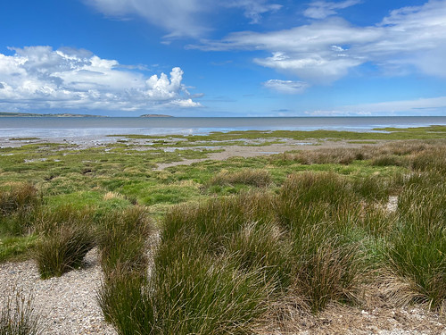
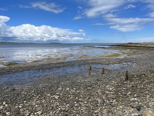
The salt marshes of Morfa Madryn
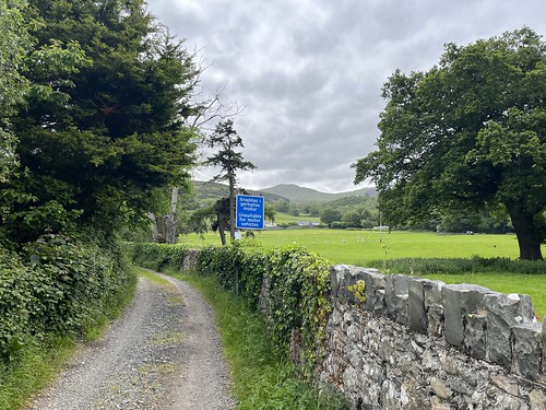
I like these Welsh slate fences – making good use of the readily available resources.
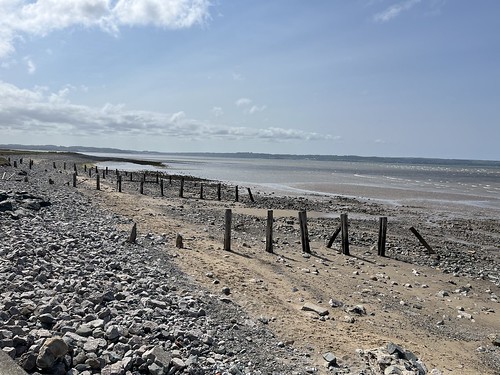
The tide was in when we set off but it was turning. Just like Morecambe Bay with the gently sloping sea bed in the Menai Straits the tide goes in and out very quickly so extensive sand and mud flats were revealed during our relatively short walk along the shore.
Even the summit of the modest hill, Foel Garreg was shrouded in the low cloud. Not a day for walking up on the high plateau.
I had to snap a phot of a favourite building – White Friars by H L North. It’s garden looking very nice indeed.
We wanted to avoid the worst of the traffic on the journey home – the M56 and M6 are awful between about 3 and 7 o’clock on a working day, so we decided to call in at Llandudno where we enjoyed an easy stroll along the broad Promenade.
The cloud was beginning to clear and the Little Orme was intermittently lit up with a shaft of sunlight
Llandudno claims an association, of sort, with Lewis Carrol’s Alice in Wonderland. The inspiration for eponymous heroine, Alice Liddell, had a holiday home, ‘Penmorfa’, on Llandudno’s West Shore. Not surprisingly, the resort take advantage of this and there’s an Alice Trail with sculptures dotted around the town. We spotted the Mad Hatter on the Prom
Time to set of for home. We’d done a total of about 10 miles altogether. Easier walking than normal for me, but still enjoyable even if the sunshine was absent.
It was a quiet drive home as hoped. probably helped by the England v Slovenia match that was on the TV that evening – I suspect folk bagged off work early. I caught some of the second half and what a dreary experience it was.
On Saturday, taking advantage of a weather window, I drove over to Llanfairfechan for a walk that took in the coastal path, a waterfall, a Roman road (allegedly!), ponies and pylons.
Parking up on the Prom car park I booted up and got ready for a walk I’ve had in mind for a while now. Nothing too adventurous and with plenty of variety. I need to get fell fit so it was a gentler walk compared to the previous week, but, typical of me, I ended up doing more than planned.
It was a high tide when I arrived – I don’t know whether it was a Spring Tide but the water level was higher than I’d seen here before. It was a glorious day too, and stayed like that right until the end of my walk.
The view towards Puffin island from the prom at Llanfairfechan
I set off west along the prom following the North Wales coastal path. there were plenty of people about, walking their dogs, birdwatching or just taking a ramble.
I passed a favourite building – an Arts and Crafts style house designed by local architect, Herbert Luck North.
White Friars by H L North
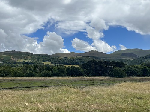
Inland, the hills were looking good. I was hoping conditions would stay like that later in the day.
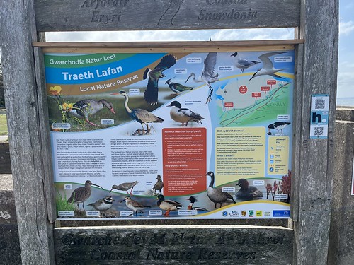
I carried on towards Traeth Lafan. The salt marshes of Morfa Madryn were inundated with sea water and teeming with bird life.
The coastal path here was submerged, but I managed to skirt it without ending up in the water.
Looking back along the path
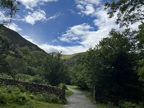
It had been chilly when I set off and was wearing my down jacket. the day was getting warmer. With the sun beating down as I walked I was heating up so stopped to lyer down, swapping my jacket for a lighter fleece hoody with a full zip. A local walker approached and stopped for a chat. He warned me that the path was flooded close to Abergwyngregyn, so after continuing for a while I cut inland on the drier, but muddy, Pentre-du path and made my way towards Aber. My plan was to walk through the village and then take the track up to the old Roman road and over the lower reaches of the Carneddau back to Llanfairfechan. But it was such a ice day I decided to extend the walk by climbing the hillside to the west of the village and follow the path to the Aber falls.
Looking down to the coast as I climbed
The route was fairly busy with people making their way back from the falls. early on I encountered some locals coming down the path as I climbed. They veered off when they saw me on the way up.
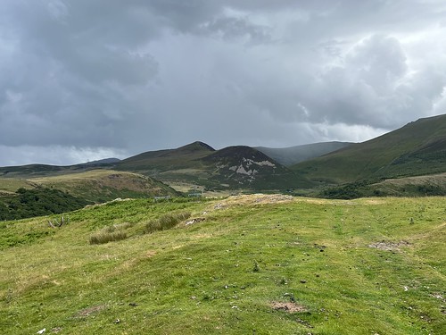
Reaching the top of the climb there was a great view over to hills to the east of the valley and I could see the route I’d be taking later in the day. Juust a few days before these hills and mountains would have been covered in snow when the cold front passed over on Thursday. There was hardly a sign of it left.
As I carried on along the path the falls eventually came into view. There’s actually two falls – the main one, Rhaeadr Fawr, which is the objective of most visitors who take the gentler route of the east side of the valley, and, over to the west, Rhaeadr Bach. They were in deep shade from the high mountains with the low winter sun, so it wasn’t so easy to take photos.
Rhaeadr Bach
Rhaeadr Fawr
I reached Rhaeadr Bach first. If you look closely at the photo you can see a couple of people who’d made their way high up the steep slope beside the falls. They’re probably wondering how to get down again!
Rhaeadr Bach
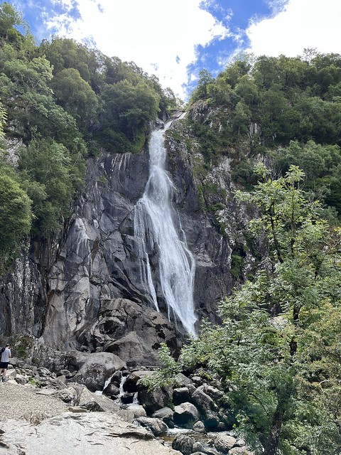
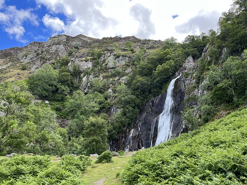
A little further along the path I reached Rhaeadr Fawr. There were plenty of people looking at the dramatic falls that plunge about 120 feet over a sill of igneous rock.
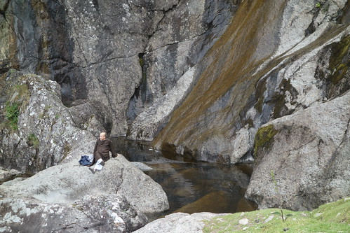
I crossed over the bridge to the other side of the river at the bottom of the falls and stopped for a while for a break to fuel up while lots of people came, took their selfies, and headed back to their cars.
Refreshed and reinvigorated I set off back down the easier path on the east side of the river until I reached the narrow, winding road that climbed up the hillside towards the wilder and rougher country below the high Carneddau mountains. It was a steep climb, tougher than I’d expected, and I had to take care to dodge the cars coming down the road from the higher car park. A couple of them, an Audi and a BMW (no surprise!) were coming down at a fair pelt, and could have quite easily hit a less wary walker or another car coming round a blind bend in the opposite direction.
Reaching the car park, a steep climb up the grassy slope
and I reached the stoney track that was, reputably, a section of the Roman road from Chester to Caernarfon.
Looking back along the Roman road
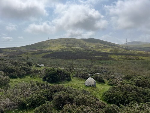
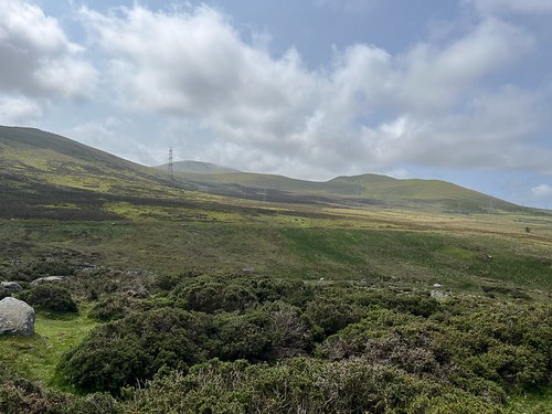
I was now on wild, higher ground with good views over to the high hills and mountains and down to the coast.
and it wasn’t long before I encountered my first little herd of Carneddau ponies.
The first time I’d been up on these slopes I’d wondered whether I’d spot any. Well, since then every time I’ve been up here I’ve seen plenty of them and this walk was no exception. It’s always great to see them. They’re not as shy as sheep, but still tend to move away if you get too close, especially if they have foals with them, as they did on this occasion.
I love this wild country up here and to have the sunny weather with clear views all around was a bonus.
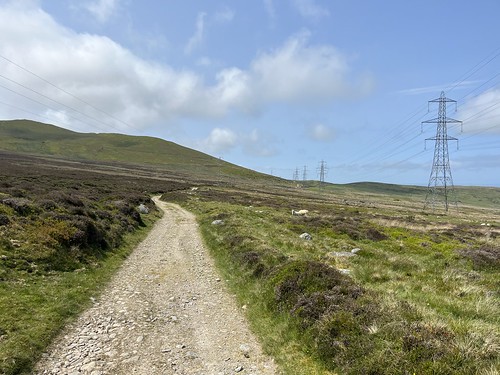
The one blot on the landscape are the string of pylons that cross the moor land, but they’re easy enough to ignore
The temperature had dropped up here with a chilly wind blowing. it was time to swop my fleece for the down jacket and put on my buff and beanie. Gloves weren’t needed though.
Other than the ponies, it’s quiet up here. I only encountered a handful of other walkers, with a trio of mountain bikers in the distance.
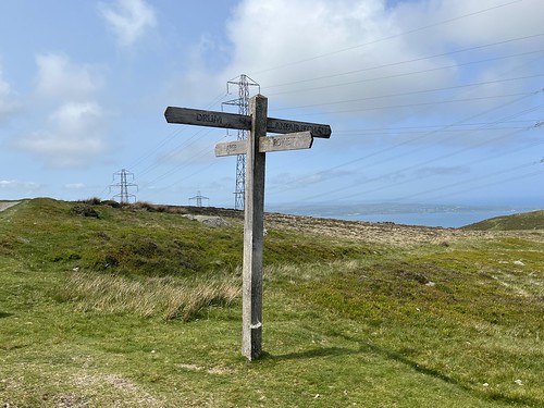
I eventually reached the fingerpost and turned off down the path towards Llanfairfechan.
Looking across to Foel Lwyd- I’d been up there last time I was up here.
Looking east towards Penmaenmawr mountain
Another shot towards Foel Lwyd, with the summit of Tal-y-fan peeping up behind
Looking back along the path towards the high mountains
Looking ahead
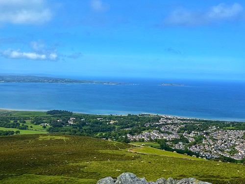
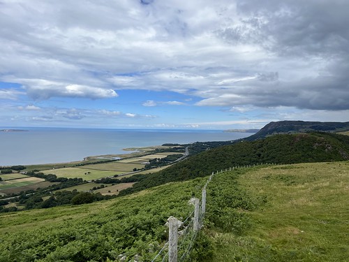
I took the fork that led to the summit of Foel Garreg, a relatively modest peak but with excellent views over the sea and mountains.
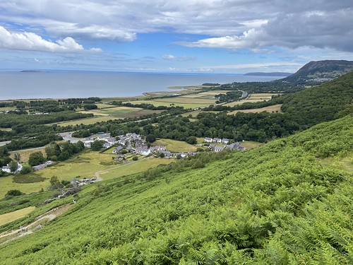
The view from the summit over Llanfairfechan to the sea – the tide was out now revealing the sands
Looking back to the mountains and, yes, another herd of ponies. In the distance I could see some snow on the flanks of Drum
It’s a steep descent down from the top – you lose a lot of height right down to sea level in a relatively short horizontal distance.
I got fairly close to the herd of ponies
Looking over the sea as I descended
and over to Penmaenmawr, lit up by the low sun that was close to setting
The last stretch of the descent of the hill was probably the worst section of the whole walk. It’s steep enough, but the ground underfoot was very wet, muddy – more slippery slutch – and if I hadn’t been using my poles it was pretty much guaranteed I’d be sliding down on my backside – I came close to it doing just that even with the support from the poles!
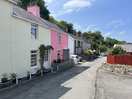
The last stretch of the route was through the old streets of upper Lanfairfechan, the original village that was home to workers in the nearby quarries. The old part of the village isn’t so pretty, although there are some attractive Arts and Crafts houses by H L North, built in the early 20th Century, in the Close to the east of the town and there are newer housing estates over that side of the town. The lower part of the town, down towards the coast was developed as a seaside resort in the late 19th century.
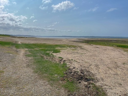
I arrived back at my car about half an hour before sunset. the tide had gone out by now, of course, revealing large stretches of sand
Looking over the sea towards Puffin island and the edge of Anglesey
The view towards the Great Orme
It been a good walk on a sunny day. A good stretch of the legs. Nothing over ambitious, although my unplanned diversion to Aber Falls had added and extra 3 1/2 miles to the route. I just can’t help myself!
Monday morning it was overcast when I got up. I’m not one for lying in (why waste the best of the day?) and I knew conditions were likely to change during the day so was hopeful of some sunshine. I was faced with a minor dilemma – should I head into the hills or go for a walk along the coast? Both have their attractions. I’d been up on the hills the day before so the coast would make a change, but then… I ended up doing both!
I always feel the coast is at its best when the sun is shining and it was still cloudy when I set out, so I thought I’d head to the hills and see what transpired. A short distance down what used to be the main road (that isn’t that busy since the through traffic is on the A55 which bypasses the town) I turned off down a quiet track with the hills in sight.
an old water fountain on Gwylt Road
It took me up to Gwylt Road, a minor road that runs parallel to the coast, turning into the Terrace Walk, with views over the town to the coast,
Looking towards the sea from the Terrace walk with Anglesey and Puffin Island visible
and then the Valley Road which eventually turned into a track up into the wilds. So a little more walking on tarmac than I like but it was a different way of accessing the fells to that I’d taken during my last break in Llanfairfechan. The Valley Road runs along the hillside above the Afon Llanfairfechan which runs through the Nant y Coed Local Nature Reserve, an attractive wooded valley.
Looking across the valley towards Penmaenmawr
Nant y Coed was once a tourist attraction created by late 19th century to local businessman John Rowland Jones, who charged visitors for entry. The estate was sold to the Local Authority in 1923 and can now be accessed and enjoyed for free. With proper planning I could have worked out a route that would have taken me through the woods, which would have been more pleasant than plodding along the tarmac. However, after passing the nature reserve the road turned into a track leading up onto the moors.
I was soon making my way through rough fields and heath
Looking back downhill towards the sea
I carried on along the track but at one point I missed a turning and ended up following what I thought was a path but turned out to be a sheep trod. A little scrambling through scrub, under low branches and over a tree that had fallen over a fence, I managed to regain the path and carried on heading upwards
Foel Lwyd ahead
Drosgyl ahead and behind it, in the distance, Y Drum
I carried on along the path until I eventually reached the old Roman road that runs along the pass through the hills towards Abergwyngeryn. Although known as the Roman Road and marked as such on the OS map, this is an ancient route that was used by prehistoric people and then later by travellers and drovers.
A long line of tall pylons carrying power lines also follows the valley. It’s hard to completely ignore them but it’s easy enough to cast your eyes to the high hills and mountains behind them or towards the sea.
It was decision time now. There were a number of options of routes up into the mountains but given that there was some low cloud and mist lingering higher up, and the sun was shining over the coast, I decided to head west along the track and then double back over Garreg Fawr towards Llanfairfechan.
I made my way to the hill that overlooks the town.
Someone had planted a Welsh flag on the top of its rocky summit
I stopped for a while – it was dinner time now so time to eat and take in the views over the sea to Anglesey and Puffin Island
to Penmaenmawr
and back over to the Carneddau
It was a steep descent back to the town
I made my way through the narrow streets
down to the promenade of the Edwardian resort
Looking east – the Great Orme in the distance
It was sunny, but somewhat windy as I set off heading west along the coast path, passing a group of houses which include three built in the the Arts and Crafts style which were designed by local architect H L North
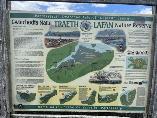
I carried on towards the salt marshes of Traeth Lafan nature reserve
Since I was here last year a number of wooden benches have been installed which feature different types of birds that breed on the marshes
one even has a panorama of the hills
Looking over the salt march with views over to the Carneddau
Reaching another Arts and Crafts style house
I left the coastal path, crossed over the railway via the railway crossing and made my way back to my accommodation. This involved walking beside the busy A55 for a short distance. It’s surprising but you don’t really notice the traffic noise when you’re on the coastal path even though the road is not that far away.
Arriving back at the flat it was time for a brew and after showering I settled down with my book for what was left of the afternoon.
Aber Falls is one of the most popular tourist attractions in northern Snowdonia. The dramatic waterfall is very accessible by an easy path making it suitable for a wide range of visitors. The falls, near to Abergwyngaren, are only a few miles from where I was staying and I had them on my list as a destination for a walk. I’d devised a lengthy route where I could walk over to the falls via the Roman road and then return via the coastal path. However, after a long hard walk up into the mountains the day before I decided to cut out a few miles by taking the bus to Abergwyngaren – the bus stop was almost opposite where I was staying.
I walked through the village and then after the falls car park I walked through the woods before joining the path along the valley that led to the falls.
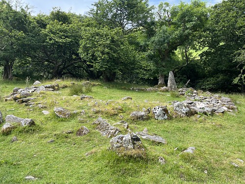
It’s about 1 1/2 miles from the car park to the falls, passing several sites of Pre-historic settlements from teh Bronze and Iron ages.
Excavated Iron Age hut circle
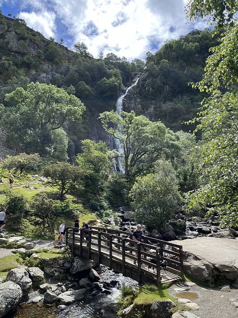
Then, there are the falls just a short distance away.
There are actually two falls – Rhaeadr Fawr and Rhaeadr Bach, the easy route leading to the former.
Rhaeadr Fawr
I stopped for a short while to take in the view of the water cascading 37 metres down from the hanging valley of Cwm yr Afon Goch, before crossing over the wooden bridge spanning the river to take in the view from the other side.
Another visitor enjoying the sunshine
A large proportion of visitors will return by retracing their steps back to the car park but there’s another option. Following the path from the bridge there’s a route that passes Rhaeadr Bach and then goes up over the moors before descending back down to the village.
Turning a corner Rhaeadr Bach was revealed. I thought that these falls which tumbled down the mountainside in a series of cascades were more interesting than the more popular (and more accessible) Rhaeadr Fawr.
I carried on along the path which looped round to the north climbing up the hill side above the valley, passing a couple of DofE exhibition groups (yes, it was that time of the year!).
Looking back there was a great view of both falls and the slopes of the Carneddau.
Height was gained gradually opening up views over the valley
and, eventually, over the sea
Looking back across to the mountains, the weather was quite different tan over the sea
My route now took me down a steep path back to the village. The picture shows how much height was gained on the return leg
Reaching the village I stopped for an ice cream and then took the minor road under the Expressway towards the coast where I joined the coastal path to walk back towards Llanfairfechan
This stretch of the coastal path passes through the Traeth Lafan Nature Reserve which stretches along the intertidal sand and mud-flats along the Menai Straits between Bangor and Llanfairfechan
I reached Morfa Madryn and then continued, retracing my route from a few days before.
The weather was much brighter this time
Looking inland
Approaching Llanfairfechan
I walked along the prom before climbing up the hill along Station Road, turning right at the crossroads for the last half mile or so back to my accommodation.